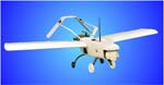
6’ Wingspan
6 Hours Flight Duration
Gimbaled Video Camera
Programmable Guidance
Geo-Fencing
Use of Multiple Fuels
180 Mile Maximum Range
65 MPH Maximum Speed
Hand or Bungee Launched
The Unmanned Aerial Vehicle (UAV), model: MFP-3, is a complete system that can operate autonomously, deliver high quality imagery, and is transported in two suitcase-sized containers. The aircraft operates autonomously, with 6 hours duration, that can be expanded to eight hours with the optional wing tanks, and burns gasoline, JP-8, Jet-A, pump diesel or kerosene without field modifications. The low replacement cost of the airborne aircraft makes it ideally suited to operations in hazardous conditions. Missions requiring autonomous flight to a remote target area, loiter and return, are easily programmed and carried out with the aid of the GPS navigation system. The MFP-3 aircraft is equipped with a standard package that consists of: an on-board 3-axis gimbaled Sony HAD color video camera, and telemetry equipment. An addition payload of 2.5 pounds can be added with the standard equipment package. The surveillance sensors on the aircraft provide transmission of their data to the ground within a 7-mile radius. Optional data links or onboard recorders can be installed for extended operational range.
The complete system consists of an airborne and ground segment. The airborne aircraft has a 6’ wingspan and contains a 26cc, 2-stroke gasoline engine. Its muffler reduces the noise level to nearly inaudible at a distance of 750 feet. The flight ceiling is 9500 feet with typical flights taking place at 650 to 1500 feet above the local terrain, with a cruising speed of 30 mph. The MFP-3 can easily operate in limited visibility conditions without danger to persons on the ground or possibility of detection. Flight proven to have flown under 200 foot cloud ceilings and in gusty winds exceeding 25 mph.
The ground system consists of a PC for command, control, and communications with the aircraft. The moving map display provides the aircraft’s location, speed, and altitude in real time. The software provides system monitoring windows to keep track of the performance data and a live video capture window. The flight path is specified as a series of mission legs, each with its own altitude, speed, and waypoint. The operator can change the mission plan by “dragging and dropping” waypoints over the map display and then uploading the new flight plan to the aircraft.